Description
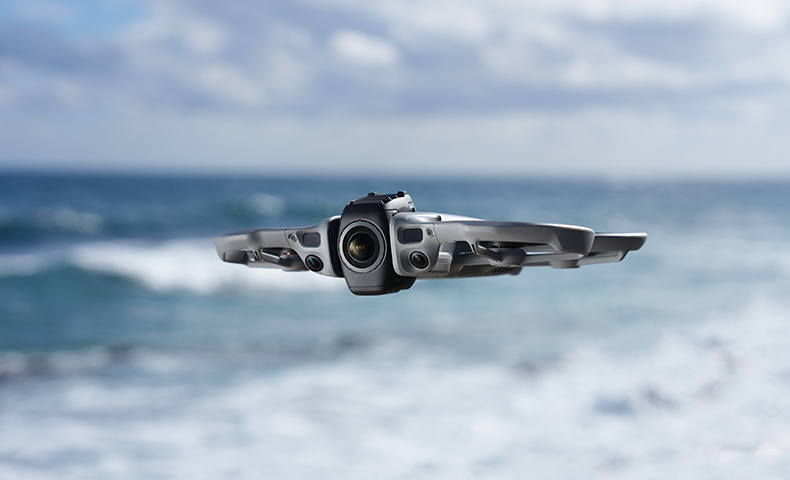
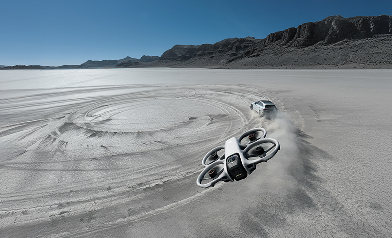
Reimagine the flight experience with flagship 360° imaging. Introducing Avata 360, capturing every epic moment in all its glory. Take to the skies, embrace the infinite, and unlock a new dimension of 360° creativity. As New Zealand's most trusted DJI experts, Ferntech is proud to offer this revolutionary platform.
.jpg)
BRILLIANT IMAGING, BOUNDLESS CREATIVITY
On a 1-inch-equivalent image field[1], your world unfolds freely in superb image quality. Capture 8K/60fps HDR video or 120MP photos with rich detail. Avata 360 disappears in the footage, leaving a pure, open view.
1-Inch Flagship Imaging[1], 8K/60fps HDR Video[2]
With 1-inch-equivalent sensors[1], large 2.4 μm pixels, and high dynamic range, light and shadow are captured with exquisite clarity. 8K/60fps HDR 360° video provides sufficient resolution for sharp cropped shots.
120MP 360° Photo[11]
Capture 120MP/16K 360° photos[11] with a single tap. Preserve the 360° world with sharp details and vast views, then reframe freely in post to create multiple distinct images.
ONE DRONE, TWO FORMS, ENDLESS FUN
Seamlessly switch from 360° to Single Lens mode for classic Avata-style filming in 4K/60fps[4].
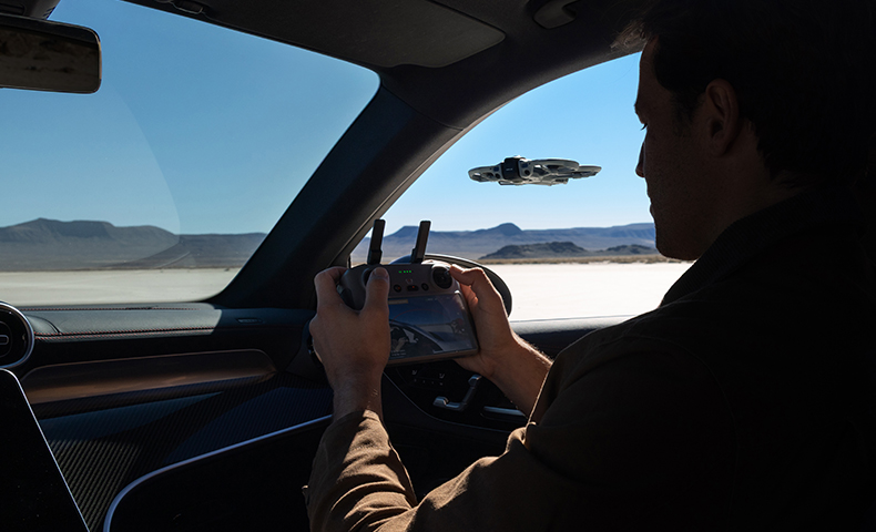
POWERFUL VIDEO TRANSMISSION, IMMERSIVE FLIGHT
Avata 360 features the O4+ video transmission system, delivering stable, clear live feeds for smoother, more immersive flight. With flexible control options, you can use it for aerial filming, immersive flight with 360° imaging, and Easy ACRO.
O4+ FHD Video Transmission
DJI O4+ video transmission system features strong anti-interference capabilities, delivers high-definition, high-frame-rate transmission at 1080p/60fps, and supports a range of up to 20 km[5].
FPV Flight & Aerial Filming in One Drone
Choose RC 2 for precise camera movement. Or use Goggles 3/N3 paired with RC Motion 3 for immersive flight with 360° imaging. Your view moves naturally with your head, making you feel like you're floating in the clouds, overlooking the world.
Dual-Channel Colour Video Transmission
When used as the main feed, both channels support 1080p/60fps. The Vision Assist view is also FHD and full colour, helping you clearly understand your surroundings.
Easy ACRO
Even beginners can use DJI RC Motion 3 to easily perform acrobatics like drifting.
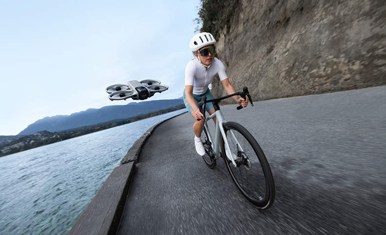
FLY WITH CONFIDENCE, CREATE WITH EASE
Even beginners can capture visually striking dynamic tracking shots with Avata 360. Omnidirectional obstacle sensing and the integrated propeller guard help you fly and film with peace of mind.
Omnidirectional Obstacle Sensing[3] & Propeller Guard
Equipped with forward-facing LiDAR, Avata 360 features nightscape omnidirectional obstacle sensing[3] in 360° mode, effective even during dynamic tracking shots. The integrated propeller guard adds another layer of safety.
ActiveTrack 360°[6]
ActiveTrack 360° automatically selects the optimal tracking mode. In Standard mode, the drone maintains a steady distance and altitude relative to the subject, while Cycling mode reacts faster to turns, keeping the subject locked and framed even in complex environments.
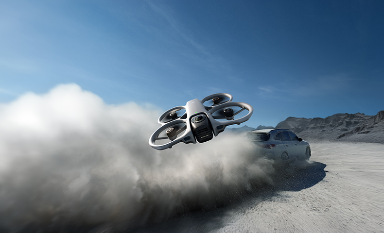
MORE DYNAMIC, MORE THRILLING
The FPV gimbal mode[2] adds a natural roll effect to Spotlight Free, ActiveTrack 360°, and manual flights, giving your footage a dynamic, FPV-style look with an intense sense of speed. You can even apply or switch to this mode in post-production.
SPOTLIGHT FREE[2] FOR INSTANT SHAREABLE FOOTAGE
No need to aim. Spotlight Free[2] locks onto a moving subject and assists with camera movement. Just fly freely, and you can replicate sophisticated camera language that once required a pro with Inspire 3, easily nailing epic shots.
Spotlight Free[2]
The Free mode in Spotlight[2] locks onto a moving subject and assists with camera movement. Simply fly and effortlessly nail epic shots—even without editing.
Spotlight
The drone's nose faces your subject, locking it in the frame. Effortlessly capture Circle or Dronie shots without manual adjustments.
INSTANT MASTERY, INSTANT MAGIC
With 360° imaging, Avata 360 brings an exceptional experience to aerial content creation. Export directly with your original perspective, or reframe in post-production, transforming a single take into multiple creative possibilities.
Infinite Creativity From One Take[2]
Capture a full 360° view in a single flight. In post, reframe from any perspective to turn one clip into multiple creations.
Unlimited Rotation, Unbound Vision
360° imaging enables infinite rotation and tilt control. Even when flying in one direction, you can effortlessly rotate the horizons, look back at beautiful scenery, make the view do a flip, smoothly zoom from standard views to Asteroid effects, or create the dolly zoom effect.
Direct Export, Instant Masterpiece
Export footage directly based on your original framing. Skip complex post-production and create cinematic work in a single, seamless step.
360° EDITING MADE EASY
Intelligent Tracking
Powered by advanced algorithms, DJI Fly and DJI Studio make it effortless to lock onto and smoothly track people, vehicles, boats, and more, even in 360° footage.
GyroFrame
In DJI Fly, simply move your phone to find and lock in your ideal angle, then export your creation with a single tap. 360° editing, made intuitive and seamless.
One-Tap Reframing
In DJI Fly and DJI Studio, you can add camera movement effects with a single tap.
Multi-Platform Editing
Edit fully in DJI Fly or DJI Studio, with DJI Studio providing rich tools for a seamless workflow. You can also create 360° masterpieces directly in Premiere with the plugin.
THOUGHTFUL DETAILS
Key details, including lenses, storage, transmission, and battery life, have all been carefully considered.
Replaceable Front Lens Element
The front lens elements feature a replaceable design. Purchase a Replacement Lens Kit With Tools[7], and you can easily replace the old lens element yourself—no need to send it in for repair.
42GB Internal Storage
With 42GB of internal storage, you can record about 30 minutes of 360° video in 8K. Capture brilliant moments instantly, even without a microSD card.
Wi-Fi 6 High-Speed Transfer
Wake Avata 360 and download footage via the DJI Fly app within Bluetooth range—no need to take out the drone. Transfer 1 GB in 10 seconds at up to 100 MB/s[8]. Downloads continue smoothly in the background, even if you switch apps.
23-Min Flight Time[9]
Avata 360 offers up to 23 minutes of flight time[9]. The charging hub supports PD fast charging and parallel charging[10], getting you back in the air quickly.
Notes
* All videos and images on this page were shot using DJI Avata 360 by professionals in strict compliance with local laws and regulations and have been variously edited in post-production.
All videos and images are for reference only. Always observe local laws and regulations and ensure the aircraft has obtained relevant certifications and airspace authorizations before flying.
** All data on this page was collected with a production model of DJI Avata 360 in a controlled test environment. Actual experience may vary depending on the environment, usage, and firmware version.
*** All images, videos, and screen display contents about the product itself on this page are for reference only. Actual product effects (including but not limited to appearance, colour, and size) and screen display contents (including but not limited to backgrounds, UI, and illustrations) may vary.
- Only available in 360° mode. When capturing 360° content, each of DJI Avata 360's two CMOS sensors features an imaging area equivalent to that of a 1‑inch CMOS sensor with a 4:3 aspect ratio.
- Only available in 360° mode.
- Conditions for enabling nightscape omnidirectional obstacle sensing: The drone's front, back, left, right, or top sides are within range of surfaces with discernible textures with illuminance that exceeds 1 lux. Similarly, the ground below is textured and diffusely reflective with a reflectivity above 20% (such as walls, trees, or people), also in lighting conditions with illuminance higher than 1 lux. DO NOT fly in severe weather conditions, such as in strong winds (wind speed of 10.7 m/s or more), snow, rain, lightning, or fog. DO NOT fly the aircraft 5,000 m (16,404 ft.) or higher above sea level. DO NOT fly the aircraft in environments where the temperature is below -10° C (14° F) or above 40° C (104° F). DO NOT take off from moving objects, such as cars or boats. DO NOT fly close to reflective surfaces such as water or snow. Otherwise, the vision system may not work correctly. The vision system may not work properly in dim environments. Always fly with caution and prevent the aircraft from entering Attitude mode. DO NOT fly near areas with magnetic or radio interference. Familiar magnetic or radio interference sources include Wi-Fi hotspots, routers, Bluetooth devices, high-voltage lines, large-scale power transmission stations, radar stations, mobile base stations, and broadcasting towers. Avoid sand entering the aircraft when taking off in desert or beach areas. Fly the aircraft in open areas away from crowds. Buildings, mountains, and trees may block the GNSS signal and affect the onboard compass. Omnidirectional Obstacle Sensing is effective only in 360° mode on surfaces with discernible textures and in lighting conditions of 1 lux or greater, and is not available when entering the playback interface. In Single Lens mode, only forward obstacle sensing is supported.
- In Single Lens mode, 4:3 aspect ratio video recording is only supported when used with Goggles 3/N3 paired with RC Motion 3 or FPV Remote Controller 3.
- Measured in an outdoor, open environment, without interference, and with FCC compliance. The 20 km transmission distance is only achievable under FCC standards; in mainland China, the SRRC standard is adopted, with a maximum transmission distance of 10 km. The above data shows the farthest communication range for one-way, non-return flights. Always pay attention to reminders in the app during your flight.
- ActiveTrack 360° requires an RC 2, RC-N2, or RC-N3 remote controller. It is recommended to use the ActiveTrack 360° feature in open environments. Refer to the user manual for unsupported scenarios or scenarios that may potentially interrupt recording. In complex environments with many obstacles, exercise caution when using Auto mode to ensure flight safety and personal safety.
- Sold separately.
- Measured using internal storage or a high-speed microSD card in a low-interference laboratory environment in countries/regions that support both 2.4 GHz and 5.8 GHz. Actual download speeds may vary.
- Measured flying at a constant 21.6 kph in a windless environment at sea level, with the camera in photo mode, from 100% battery level until 0%. Data is for reference only. Always pay attention to reminders in the live view during your flight.
- Parallel charging requires the DJI 65W Portable Charger or DJI 100W USB-C Power Adapter. With an input of 65 W or higher, the hub supports parallel charging. Otherwise, it charges sequentially, prioritizing the highest battery level.
- For 120MP/16K 360° photos, the resolution is 15520×7760 (120 MP) in JPEG and 15360×7680 (118 MP) in DNG.
PRODUCT SPECIFICATIONS
AIRCRAFT
Takeoff Weight: Approx. 455 g
Dimensions: 246×199×55.5 mm (L×W×H)
Max Ascent Speed: 2 m/s (Cine mode)
6 m/s (Normal mode)
10 m/s (Sport mode)
Max Descent Speed: 1.5 m/s (Cine mode)
6 m/s (Normal mode)
10 m/s (Sport mode)
Max Horizontal Speed: At sea level, in windless conditions:
6 m/s (Cine mode)
16 m/s* (Normal mode)
18 m/s (Sport mode)
Measured in a controlled wind tunnel environment under conditions equivalent to windless operation and sea-level altitude, with the aircraft ascending vertically to a height of 1.5 meters above the ground. Actual experience may vary depending on the environment, usage, and firmware version.
* Up to 12 m/s in Normal mode by default, adjustable to 16 m/s in settings.
Max Takeoff Altitude: 4500 m
Measured in a windless environment when taking off from an altitude of 4500 m and ascending vertically by 500 m, using Sport mode, and from 100% battery level until 20%. Data is for reference only. Always pay attention to reminders on the camera view during your flight.
Max Flight Time: Approx. 23 mins
Measured in a controlled wind tunnel environment under conditions equivalent to windless operation and sea-level altitude, with the aircraft flying forward at a constant speed of 21.6 kph, Obstacle Avoidance Action set to Brake, and the camera in Photo mode, until a forced landing due to battery depletion. Actual experience may vary depending on the environment, usage, and firmware version.
Max Hovering Time: Approx. 22 mins
Measured when hovering in a windless environment at sea level, and the camera in photo mode, until a forced landing due to battery depletion. Data is for reference only. Actual experience may vary depending on the environment, usage, and firmware version.
Max Flight Distance: 13.5 km
Measured in a controlled wind tunnel environment under conditions equivalent to windless operation and sea-level altitude, with the aircraft flying forward at a constant speed of 39.6 kph, Obstacle Avoidance Action set to Brake, and the camera in Photo mode, until a forced landing due to battery depletion. Actual experience may vary depending on the environment, usage, and firmware version.
Max Wind Speed Resistance: 10.7 m/s (Level 5)
Max Pitch Angle: 48°
Operating Temperature: -10° to 40° C (14° to 104° F)
Global Navigation Satellite System: GPS + Galileo + BeiDou
Hovering Accuracy Range: Vertical:
±0.1 m (with vision positioning)
±0.5 m (with satellite positioning)
±0.3 m/3 mins (with ETK positioning)
Horizontal:
±0.3 m (with vision positioning)
±1.5 m (with satellite positioning)
±0.3 m/3 mins (with ETK positioning)
Internal Storage: 42 GB
Class: C1 (EU)
CAMERA
Image Sensor: Two 1/1.1-Inch Square CMOS Sensors
Effective Pixels per Sensor: 64MP
Lens: FOV: 200°
Format Equivalent: 7.8 mm
Focal Length: 2.5 mm
Aperture: f/1.9
Focus mode: FF
Focus: 1.5 m to ∞
ISO Range: 360° Video:
8K@60/50/48fps: 100-12800 (Normal/D-Log M)
8K@30/25/24fps: 100-25600 (Normal), 100-12800 (D-Log M)
6K@60/50/48/30/25/24fps: 100-25600 (Normal), 100-12800 (D-Log M)
360° Photo: 100-6400
Single-Lens Video: 100-12800
Shutter Speed: Video: 1/8000-1/25 s
Photo: 1/8000-1/30 s
Still Photography Mode: Single Shot:
In 360° mode, the resolution is 30 MP* or 120 MP**.
* For 30MP/8K 360° photos, the resolution is 7776×3888 (30 MP) in JPEG and 7680×3840 (29.49 MP) in DNG.
** For 120MP/16K 360° photos, the resolution is 15520×7760 (120 MP) in JPEG and 15360×7680 (118 MP) in DNG.
Max Image Size: 360° Photo: 15520×7760
Photo Format: JPEG/DNG
Video Resolution: 360° Mode:
8K (2:1): 7680×3840@60/50/48/30/25/24fps
6K (2:1): 6000×3000@60/50/48/30/25/24fps
Single Lens Mode:
4K (4:3)*: 3840×2880@60/50/48/30/25/24fps
4K (16:9): 3840×2160@60/50/48/30/25/24fps
2.7K (4:3)*: 2688×2016@120/100/60/50/48/30/25/24fps
2.7K (16:9): 2688×1512@120/100/60/50/48/30/25/24fps
* Only supported when using DJI Goggles 3/N3 paired with DJI RC Motion 3 or DJI FPV Remote Controller 3.
Video Format: OSV/MP4 (H.265)
Max Video Bitrate: 180 Mbps
Color Mode: Normal
D-Log M
EIS: Single Lens Mode:
With RC 2/RC-N2/RC-N3: Supports only RockSteady
With Goggles 3/N3 paired with RC Motion 3 or FPV Remote Controller 3: Supports a switch between RockSteady and HorizonBalancing
Camera FOV: Single Lens Mode:
With RC 2/RC-N2/RC-N3: Natural Wide
With Goggles 3/N3 paired with RC Motion 3 or FPV Remote Controller 3: Standard (Dewarp)/Wide/Natural Wide
Supported File System: exFAT
GIMBAL
Stabilization: Single-Axis Mechanical Gimbal (tilt)
360° Virtual Gimbal
Controllable Range: Single-Axis Mechanical Gimbal:
Tilt (With RC 2/RC-N2/RC-N3): -30° to 60°
Tilt (With Goggles 3/N3 paired with RC Motion 3 or FPV Remote Controller 3): -60° to 60°
360° Virtual Gimbal:
Tilt: -180° to 180°
Roll: -180° to 180°
Max Control Speed: Single-Axis Mechanical Gimbal:
Tilt: 100°/s
360° Virtual Gimbal:
Tilt: 100°/s
Roll: 100°/s
Angular Vibration Range: Single-Axis Mechanical Gimbal:
±0.01°
SENSING
Sensing Type: Omnidirectional vision system, supplemented with forward-facing LiDAR and an infrared sensor at the bottom of the aircraft
Forward: Measurement Range: 0.5-20 m
FOV: Horizontal 90°, Vertical 90°
Backward: Measurement Range: 0.5-18 m
Lateral: Measurement Range: 0.5-18 m
Upward: Measurement Range: 0.5-18 m
Downward: 3D ToF Effective Measurement Height: 10 m
Precise Hovering Range: 0.3-10 m
3D ToF FOV: Horizontal 60°, Vertical 60°
Measurement Range: 0.5-20 m
FOV: Horizontal 90°, Vertical 90°
Operating Environment: Diffuse reflective surfaces with discernible patterns, diffuse reflectivity > 20% (such as concrete pavement)
Adequate lighting (lux > 1, normal indoor lighting conditions)
VIDEO TRANSMISSION
Video Transmission System: O4+
Live View Quality: Single Lens Mode:
1080p@100*/60/50/48/30/25/24fps
360° Mode:
1080p@60/50/48/30/25/24fps
* In Single Lens Mode, 1080p/100fps is supported only when the aircraft is used with Goggles 3/N3 and RC Motion 3.
Operating Frequency: 2.400-2.4835 GHz
5.170-5.250 GHz*
5.725-5.850 GHz
* 5.170-5.250 GHz can be used only in countries and regions where permitted by local laws and regulations.
Transmitter Power (EIRP): 2.400-2.4835 GHz:
< 33 dBm (FCC)
< 20 dBm (CE/SRRC/MIC)
5.170-5.250 GHz:
< 23 dBm (CE)
5.725-5.850 GHz:
< 33 dBm (FCC)
< 30 dBm (SRRC)
< 14 dBm (CE)
Communication Bandwidth: Max 40 MHz
Max Transmission Distance (unobstructed, free of interference): FCC: 20 km
CE: 10 km
SRRC: 10 km
MIC: 10 km
Measured in an unobstructed outdoor environment free of interference. The above data shows the farthest communication range for one-way, non-return flights under each standard. Always pay attention to RTH reminders on the camera view during your flight.
Max Transmission Distance (unobstructed, with interference): Strong Interference: Urban landscape, approx. 1.5-5 km
Medium Interference: Suburban landscape, approx. 5-12 km
Low Interference: Suburb/seaside, approx. 12-20 km
Data tested under FCC standard in unobstructed environments with typical interference. Used for reference purposes only and provides no guarantee for actual transmission distance.
Max Transmission Distance (obstructed, with interference): Low Interference and Obstructed by Buildings: Approx. 0-0.7 km
Low Interference and Obstructed by Trees: Approx. 0.7-4.5 km
Data tested under FCC standard in environments with typical low interference. Used for reference purposes only and provides no guarantee for actual transmission distance.
Lowest Latency: With RC 2/RC-N2/RC-N3:
1080p/60fps Video Transmission Quality: Approx. 130 ms*
* Actual experience may vary depending on the environment, usage, and firmware version.
Max Video Bitrate: 60 Mbps
Max Download Speed: O4+: 10 MB/s
Wi-Fi 6: 100 MB/s*
* Measured in a laboratory environment with little interference in countries/regions that support both 2.4 GHz and 5.8 GHz, and when internal storage or a high-speed microSD card is used. Download speeds may vary depending on the actual conditions.
Antennas: 4 antennas, 2T4R
INTELLIGENT FLIGHT BATTERY
Capacity: ≥ 2700 mAh
Weight: Approx. 149 g
Nominal Voltage: 14.32 V
Max Charging Voltage: 17.2 V
Battery Type: Li-ion
Energy: ≥ 38.67 Wh
Discharge Rate: 7C (typical)
Charging Temperature: 5° to 40° C (41° to 104° F)
Charging Time: With Charging Hub (100W max charging power):
One Battery, From 0 to 100%: Approx. 47 min
One Battery, From 10 to 90%: Approx. 31 min
Three Batteries, From 0 to 100%: Approx. 100 min
Three Batteries, From 10 to 90%: Approx. 70 min
Directly Charging the Drone (65W max charging power):
One Battery, From 0 to 100%: Approx. 73 min
One Battery, From 10 to 90%: Approx. 51 min
Data tested under laboratory conditions at 25° C (77° F) and can be used for reference only. Actual charging time may increase due to higher ambient temperatures or variations in mains voltage between regions.
CHARGER
Recommended Charger: Supports DJI 65W Portable Charger and DJI 100W USB-C Power Adapter
With Charging Hub: DJI 100W USB-C Power Adapter is recommended.
BATTERY CHARGING HUB
Input: 5-20 V, max 5 A
Output (power accumulation): Max 60 W
Output (charging): Max 17.2 V
Output (USB): 30 W
Charging Type: Supports Charging up to Three batteries Simultaneously
Parallel charging requires the DJI 65W Portable Charger or DJI 100W USB-C Power Adapter. With an input of 65 W or higher, the hub supports parallel charging. Otherwise, it charges sequentially, prioritizing the highest battery level.
Compatibility: DJI Avata 360 Intelligent Flight Battery
STORAGE
Recommended microSD Cards: Lexar SILVER PLUS 64GB A2 V30 microSDXC
Lexar SILVER PLUS 128GB A2 V30 microSDXC
Lexar SILVER PLUS 256GB A2 V30 microSDXC
Lexar SILVER PLUS 512GB A2 V30 microSDXC
Lexar SILVER PLUS 1TB A2 V30 microSDXC
Kingston CANVAS GO! Plus 64GB A2 V30 microSDXC
Kingston CANVAS GO! Plus 128GB A2 V30 microSDXC
Kingston CANVAS GO! Plus 256GB A2 V30 microSDXC
Kingston CANVAS GO! Plus 512GB A2 V30 microSDXC
Using Lexar SILVER PLUS series microSD cards may deliver a better photography experience.
WI-FI
Protocol: 802.11 a/b/g/n/ac/ax
Operating Frequency: 2.400-2.4835 GHz
5.725-5.850 GHz
Transmitter Power (EIRP): 2.4000-2.4835 GHz:
< 20 dBm (FCC/CE/SRRC/MIC)
5.725-5.850 GHz:
< 26 dBm (FCC/SRRC)
<14 dBm (CE)
BLUETOOTH
Protocol: Bluetooth 5.4
Operating Frequency: 2.4000-2.4835 GHz
Transmitter Power (EIRP): < 10 dBm
IN THE BOX
DJI Avata 360 × 1
DJI RC 2 × 1
DJI Avata 360 Intelligent Flight Battery × 1
DJI Avata 360 Gimbal Protector × 1
DJI Avata 360 Spare Propellers (Pair) × 2
Screwdriver × 1
DJI Avata 360 Foldable Landing Pad × 1
DJI Avata 360 Lens Cleaning Cloth × 1
USB-C to USB-C Data Cable × 1
Documents (Quick Start Guide, Safety Guidelines, and DJI Logo Stickers) × 1


